Strawberry Lake Trail #5
The Strawberry Lake trail is 2.8 miles long and climbs 1,500 feet. It begins at the end of Forest Service Road #5390 and ends at the junction with Alpine Trail #7. This trail switchbacks up a wooded ridge and then flattens out and sidehills for the last 1.5 miles to the alpine lake. The trail is open for the following uses: Hiking, horseback riding, mountain biking, and motorcycle trail riding.
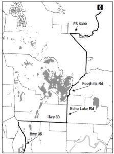 Directions:
From Bigfork, go North on Highway 35 for 2.3 miles and turn right onto Highway 83. Stay on 83 for 2.8 miles and turn left onto Echo Lake Rd. After 2.2 miles, turn slightly right onto Foothill Rd. bear left after 1.1 miles to stay on the Foothill Rd. Drive for 2.7 miles, then turn right onto Road 5390 and drive for 3.3 miles, the trailhead is located at the end of this road.
Length : 2.8 miles
Elevation : 4,137 feet – 5,611 feet
Don’t need the hiking guide, just some basic trail information, do not fret. Mike has included some beginner to medium hikes on this website. Depending on were you as staying there is most likely a trail head near you. Thanks for visiting, hope to see you on the trail.
The trail guide is focused on trails, camping and being in the woods. Mike’s Flathead Lake Trail Guide breaks the area in five easy to use sections. North of Flathead lake, including The Talley Lake area and due north to Polebridge. East of Flathead Lake, including the Swan Front, Swan Valley, and on into the Hungry Horse recreation area. The guide contains most every trail Mike has hiked in the last 20 years or plans to hike in the next 20 years.

