

The Estes Lake trail is 1.5 miles long. It begins at the junction with Road #498 and ends at Estes Lake.
[embedyt] https://www.youtube.com/watch?v=g8HE4aXsqVQ[/embedyt]
The trail starts out climbing slightly, goes over a knoll, and then descends, winding through the topography and between small wetlands; there is a small cedar grove near the lake. Estes Lake is a tannic lake bordered by lily pads and scattered with blue dragon flies (depending on the time of year).
The trail is open for Off Highway Vehicles (OHV) less than or equal to 50 inches wide, 2 wheeled vehicles, mountain biking, horseback riding, and hiking.
Estes Lake trail directions, from Bigfork, go south on Highway 35 for 0.7 miles, turning left onto Hwy 209. Stay on 209 for 3 miles, turning right at the light onto South Ferndale Rd. After 2 miles, merge right.

Mike has been up and down this trail many times. It is a favorite for out of area friends and guests. If you want to make it interesting you can begin the trail down and it breaks off to many different points. The beauty is it is really hard to get lost. If you Hike down you end at Flathead Lake, or Crane Mountain. In either case civilization is just around the corner.
If you are hiking somewhere other then around Montana’s Flathead Lake be sure to check out the Top 100 Hiking Blogs from Feed Spot.

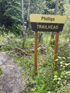 Hike Flathead Lake on Phillips Trail #373. Phillips Trail #373 is 3.8 miles long and climbs about 600 feet; it intersects with Crane Mtn Road #498 and the
 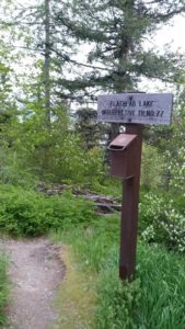 This short, family friendly 0.4 mile loop interpretive Flathead Lake trail. The short but steep distance down to excellent view of Flathead Lake and the western skyline. This trail was developed in partnership with the Bigfork High School.
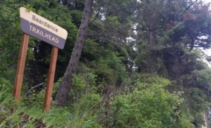 The Flathead Lake Bear Dance Trail is 6.7 miles long and climbs about 2,200 feet. It begins off of Highway # 35 from the Beardance Trailhead and follows Forest Road #10222 and terminates at Crane Mountain Road #498. The trail is open to: hiking, horseback riding, and mountain biking.
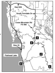 Directions: From Bigfork go south on Highway 35 past Woods Bay and turn right after mile marker 23, entering the Beardance trailhead parking. The trailhead is on the east side of the highway.