

Mission Mountains Wilderness
Located in the Flathead National Forest in Montana.
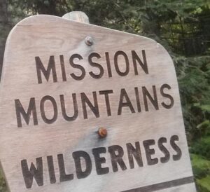
The Mission Mountains Wilderness is on the Swan Lake Ranger District of the Flathead National Forest in northwestern Montana. The Forest Service manages it as part of the National Forest System. Officially classified as Wilderness on January 4, 1975, the 73,877 acre area is managed in accordance with the Wilderness Act of 1964. The Mission Mountains run along the east shore of Montana’s Flathead Lake.
When to Visit – Most people visit the wilderness between July 1 and October 1. Snow-filled passes and high streams make earlier travel difficult and hazardous. High lakes do not open up until early or mid-June.
June is normally a wet month. Snow still covers high, shaded basins and surrounds trees.
July, August, and early September are dry months. Daytime temperatures are the 80-90 degree range. Showers are frequent. Nights are very cool. Snow occur at any time. Heavy snow generally occurs in late October and early November.
If you are a skier or winter camper, late February through May provide the best snow conditions and longer days. When planning an extended backcountry trip, be informed of potential avalanche conditions.
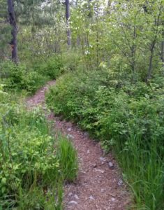
Trails – There are about 45 miles of maintained Forest Service system trails in the Mission Mountains. Most trails are better suited to hiking than horseback riding because of rugged terrain.
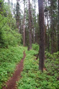 Travel is primarily by foot with some horseback use. Mountain bikes, hang gliders, motorized trail bikes, motorcycles, three and four wheelers, and snowmobiles are not permitted. Few of the trails can be called easy. Some are especially difficult because of steepness. You should be an experienced hiker to travel cross country and should possess map reading and compass skills.
Throughout the Mission Mountains you will find old Indian and packer trails. These are usually steep and difficult to follow. They are suitable for only the most experienced horse users or backpackers.
Access Points – The major access points into the Mission Mountains Wilderness from the Swan Valley: Glacier Creek, Cold Lakes, Piper Creek, Fatty Creek, and Beaver Creek. Other access points from the Swan Valley include Lindbergh Lake (south end trail reached by boat), Jim Lakes, Hemlock Creek, Meadow Lake, and Elk Point.
There are also three major access points from the Salish & Kootenai Indian Reservation side of the Mission Mountains. Access through tribal lands requires a permit. These permits may be purchased at major sporting goods stores in Missoula and the Mission Valley or through the Confederated Salish and Kootenai Tribal Recreation Department in Pablo, Montana, phone (406) 675-2700.
A major portion of the Mission Mountains is suitable for backpacking only. Travel is strenuous, but it has many advantages: independence and self-sufficiency, opportunities for solitude, and you’re more carefree when backpacking.
DAY HIKES: The Mission Mountains has several hikes ranging from 1 1/4 miles to 6 miles (one way) which can be completed in a day. You will carry less on your back and travel more easily.
BACKPACKING: Backpacking requires careful planning. Proper equipment, with maximum utility and minimum weight, will make the trip easier. The most important items will be your pack, sleeping bag, and foot gear. Take only what you need. A pack that is too heavy can spoil your trip. A pack without adequate food, clothing and shelter can be equally disappointing and unpleasant.
The Go Hike With Mike trail guide contains most every trailhead along the Swan front of the Mission Mountains.
[embedyt] https://www.youtube.com/watch?v=DJxzOLibbOc[/embedyt]


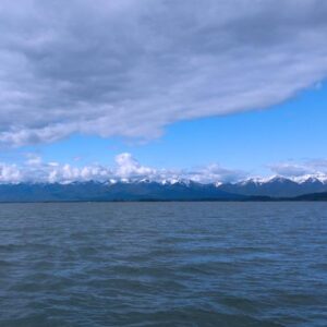 Flathead Lake is the largest natural freshwater lake in the western United States. Lying in the Flathead Valley of Northwest Montana, the lake is more then 300 feet deep and extends north and south some 28 miles and is seven to 15 miles wide.
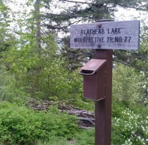 You can avail yourself of a boat tour or rent one of the many types of watercraft including canoes, kayaks, windsurfers, hydro bikes, sailing and fishing boats. Serious anglers can arm themselves with heavy-duty equipment and probe the 300-foot deep
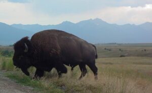 A large portion of the 18, 500 acre Range consists of native Palouse prairie; forests, wetlands, and streams are also found here providing a wide range of habitats for wildlife. Elk, deer, pronghorn, black bear, coyote and ground squirrels are just some of the mammals that share the area with 350 to 500 bison. Over 200 species of birds also call this home including eagles, hawks, meadowlarks, bluebirds, ducks, and geese.
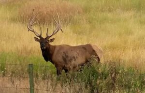 Prairie Drive/West Loop: a 5-mile gravel road that travels through the flats. It is open to trailers and large RVs. It goes by the Bison Display Pasture. Plan for 1/2 hour. Open year round.


 The trail guide is focused on trails, camping and being in the woods. Mike’s
 The Flathead River, in the northwestern part of Montana, originates in the Rocky Mountains near