

[embedyt] https://www.youtube.com/watch?v=XA6xMJa0pz8[/embedyt]
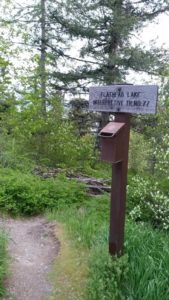 This short, family friendly 0.4 mile loop interpretive Flathead Lake trail. The short but steep distance down to excellent view of Flathead Lake and the western skyline. This trail was developed in partnership with the Bigfork High School.
If you have the opportunity to visit this trail during the month of May the may Flowers will be in full bloom. The trail is a little steep going down. However, it is very manageable for young and old alike. The view from this Flathead Lake trail is exceptional. At points on the trail you will see north into Woods Bay as well as east to Wildhorse Island. Once at the bottom of this short trail be sure to refresh yourself with a plunge into the blue waters of Flathead Lake.
At a Glance
Usage: Light
Closest Towns: Bigfork
Water: No
Directions: To get to this trail head from Bigfork, go south on Highway 35 past Woods Bay, and turn right after mile marker 23, entering the Beardance trailhead parking. The trail goes downhill from both parking areas, creating a loop.
Location
Latitude : 47.95622819
Longitude : -114.0329612
Elevation : 3,071 feet – 3,071 feet
There is no camping at this trail head. Camping is available in Wayfarers State Park about 10 miles to the north in Bigfork.
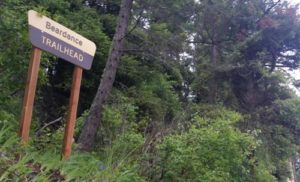 The Flathead Lake Bear Dance Trail is 6.7 miles long and climbs about 2,200 feet. It begins off of Highway # 35 from the Beardance Trailhead and follows Forest Road #10222 and terminates at Crane Mountain Road #498. The trail is open to: hiking, horseback riding, and mountain biking.
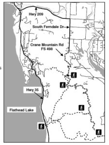 Directions: From Bigfork go south on Highway 35 past Woods Bay and turn right after mile marker 23, entering the Beardance trailhead parking. The trailhead is on the east side of the highway.