
Hiking Trail: Crater Notch Trail #187
The Crater Notch Trail is 3.7 miles long and climbs about 3,000 feet. It begins 1/2 mile up the Echo-Brokenleg Trail #544 and ends at the Alpine Trail #7 leading to In-thlam-keh Lake. The trail is open for the following uses for the first 2.7 miles: hiking, horseback riding, and mountain biking. After 3.5 miles the trail enters the Jewel Basin Hiking Area where the only allowed use is hiking. Please respect these guidelines.
Usage is typically light, closest town is Bigfork Montana.
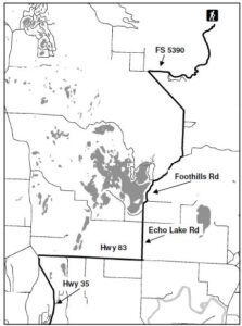
Directions:
From Bigfork, go north on Highway 35 for 2.3 miles and turn right onto Hwy. 83. Stay on 83 for 2.8 miles, turning left onto Echo Lake Rd. After 2.2 miles, merge slightly right onto the Foothills Road. After 1.1 miles turn right onto Road #5392 also called Jewel Basin Rd. The trailhead is about two miles up the road on the right.
Location
Area/Length : 3.7 miles
Elevation : 3,255 feet – 6,175 feet
 Directions: