Tally Lake Campground.

Tally Lake Campground is located on the northern shores of its namesake lake, west of Whitefish, Montana. The campground is popular with locals and tourists visiting the Flathead National Forest and offers a variety of recreation facilities and activities for the whole family.

Natural Features:
The campground is nestled in the highlands of northwestern Montana, adjacent to Tally Lake, the second deepest Lake in Montana 445 feet deep. It sits in a mature forest of Western Larch and Douglas fir trees.

Recreation:
Hiking, horseback riding and biking trails wind around the Tally Lake Campground and the lake. Wildlife like waterfowl, bald eagles and migratory birds are commonly spotted. A dock provides access to the lake’s best fishing, which includes kokanee salmon, a variety of trout and northern pike. Visitors also enjoy boating, water skiing and other water recreation on the 1,326 acres of Tally Lake.

Hiking in Montana

Facilities:
The campground offers dozens of campsites for tent and RV camping. It provides access to a boat ramp, an open air pavilion, beaches and picnic areas. Campsites are equipped with tables and campfire rings with grills. Accessible vault toilets and drinking water are provided. An on-site host is available to answer questions and provide additional information. The campground has 40 campsites, boat launch, open air pavilion, beach area, picnic site, water and hosts on site during the summer months. The Tally Lake Pavilion is a beautiful timber frame open air pavilion. The site has parking for 50 vehicles, a double vault toilet, picnic tables, fire grill, group fire ring, horse pit, volleyball court, and nature trail. The pavilion is centrally located within the Tally Lake Campground. There are several trails nearby and two trails within the campground. One group site (site 39) and the pavilion can be reserved through the national recreation website. Firewood is generally for sale by the host.

Nearby Attractions:
The popular Whitefish Lake is about 20 miles from the campground. Visitors to the area also enjoy the Forest Service Summit Nature Center at Whitefish Mountain Resort, located about 25 miles away and accessed by the resort chairlift or the Danny On hiking trail.

Reservations:
This site can be reserved by calling Toll Free 1-877-444-6777 (International 518-885-3639 or TDD 877-833-6777 or on-line at Recreation.gov.

“Annual Season Pass” for access to those day use facilities located on the Flathead National Forest which are under Flathead Valley Campground (FVC) management, will be available for purchase from any of the concession facilities. This annual pass will cost $35.00, and will be available for the calendar year in which it was purchased. Note: Two passes may be purchased for $55.00 to accommodate a second family vehicle, only if the second vehicle is present. FVC will offer a 50 percent discount on all standard site fees and day use fees to holders of the Golden Age and Golden Access Passports, as well as holders of the Interagency Senior and Access Passes. Discounts will not be offered to holders of the Interagency Annual or Volunteer Pass. There will be no discount offered on group site reservations, boat rentals, dump fees, extra vehicle fees or firewood sales.

General Information
Directions: From Whitefish take Hwy 93 west 10 miles, turn onto Farm-to-Market Rd go 1.5 miles, turn onto the Star Meadow Road go 9 miles, turn onto FS Rd #913 go approximately 3.25 miles. Look for the campground entrance sign.

The Flathead Lake Vacation Guide

Sunset over Flathead Lake

The Flathead Lake Vacation Guide includes annual events, lodging, trail heads for hiking, private campgrounds and information about every State Park around Flathead Lake. Find out more….

The Guide contains more than 70 pages of information including links to activities, local business listings, , public campgroundshiking trailsfishing access sites and just about any other information you want when you vacation on Flathead Lake.

The Flathead Lake Vacation Guide is easy to use. The Guide contains information about each community, complete with business listings and public access points.  The Guide also contains many of the Trail Heads along Glacier View road, as well as the Jewel Basin outside of Bigfork Montana.

The Flathead Lake Vacation Guide

The Guide contains every public access point around The Lake. It also contains most every private campground as well. So if you are looking for public or private campgrounds around our Lake, this vacation guide has the information you will need to plan your Montana vacation.

Flathead Lake Vacation Guide

Communities on Flathead Lake

Communities included in the Guide include the population centers such as Bigfork, Lakeside and Polson, as well as the smaller communities like Woods Bay, Finely Point or Big Arm. All of the Montana State Parks are listed in this vacation guide. Including Yellow Bay, Flathead Lake Trail and Finley Point State Park. The guide contains many photographs as well as information you will want during your vacation.

The guide costs $6.99 and is an instant download to your computer or mobile device. Of course the Guide comes with a money back guarantee. It’s like having all of the local information right on your phone.

Purchase your guide, either for your phone on in you hand.

The Flathead Indian Reservation

Flathead Lake Montana

Welcome to the Flathead Indian Reservation.

Let’s take a moment to consider the history that took place to allow you to enjoy all of the recreational and hiking opportunities Flathead Lake has to offer.

The southern half of Montana’s Flathead Lake resides on the Flathead Indian Reservation.  This is Indian Country. The Hellgate Treaty of 1855 set this land aside for the Salish, Kootenai and Pend Oreille Tribes.

Charlo, or Charlot, was the son of Victor, and his successor as chief of the Salish bands. The Treaty of 1855, negotiated by Isaac Stevens, had guaranteed that Victor and his people could stay in the Bitterroot Valley. In 1872, however, President U.S. Grant ordered the Salish, then led by Chief Charlo, to move north to the Flathead Reservation. Two sub-chiefs, Arlee and Joseph Nine Pipes, complied, but Charlo refused, and stayed resolutely, but “illegally,” on his native lands.

In 1876, the government of Montana Territory proposed a tax on Indians’ property. Charlo’s bitter but eloquent response resonates with his deep sadness and disillusionment.

Chief Charlo’s Answer

Since our forefathers first beheld [the white man], more than seven times ten winters have snowed and melted. Most of them like those snows have dissolved away. Their spirits went whither they came; his, they say, go there too. Do they meet and see us here? Can he blush before his Maker, or is he forever dead? Is his prayer his promise—a trust of the wind? Is it a sound without sense? Is it a thing whose life is a foul thing?…

What is he? Who sent him here? We were happy when he first came; since then we often saw him, always heard him and of him. We first thought he came from the light, but he comes like the dusk of the evening now, not like the dawn of the morning. He comes like a day that has passed, and night enters our future with him.…

Had Heaven’s Chief burnt him with some mark to refuse him, we might have refused him. No, we did not refuse him in his weakness; in his poverty we fed, we cherished him—yes, befriended him, and showed the fords and defiles of our lands. Yet we did think his face was concealed with hair, and that he often smiled like a rabbit in his own beard. A long-tailed, skulking thing, fond of flat lands, and soft grass and woods.

To confirm, his purpose; to make the trees and stones and his own people hear him, he whispers soldiers, lock houses and iron chains.…He, the cause of our ruin, is his own snake, which he says stole on his mother in her own country to lie to her. He says his story is that man was rejected and cast off. Why did we not reject him forever? He says one of his virgins had a son nailed to death on two cross sticks to save him. Were all of them dead then when that young man died, we would be all safe now and our country our own. . . .

…His meanness ropes his charity, his avarice wives his envy, his race breeds to extort. Did he speak at all like a friend? . . .

He is cold, and stealth and envy are with him, and fit him as do his hands and feet. We owe him nothing; he owes us more than he will pay, yet he says there is a God.…

His laws never gave us a blade nor a tree, nor a duck, nor a grouse, nor a trout. No; like the wolverine that steals your cache, how often does he come? You know he comes as long as he lives, and takes more and more, and dirties what he leaves.”

In 1891, after 20 more years of impoverishment and near-starvation, Charlo agreed to move his band of 157 people to the Flathead Reservation. They walked the seventy-five miles from their ancestral homeland in the Bitterroot Valley to the Jocko Valley at the southern end of the reservation.


CSKT Tribal Recreation Permits

Recreation Permits: Camping and Hiking in the Mission Mountain Tribal Wilderness:

Camping around Flathead lakeThe Mission Mountains Tribal Wilderness is located on the western slopes of the Mission Range. The area covers approximately 91,778 acres. It is roughly 34 miles long and five miles wide. Elevations range from four thousand to nearly ten thousand feet.

All recreational activities on Tribal owned lands require a non-member person over the age of 11 to purchase a Tribal Conservation Permit. All non-members must have on their person; whenever engaged in recreation activities on Tribally owned lands of the Reservation, a valid Flathead Reservation Use Permit, and any additional bird, fishing, or camping stamps as required. Certain Tribal campgrounds and recreation areas may have special regulations, which are posted, on site.

NOTE: Recreation Permits must be purchased in person initially from a retail outlet/Reservation Permit vendor to register. After that first registration you can purchase online. Reservation Permits are available on the internet at http://app.mt.gov/Als/Index

Pablo, MT at Zimmer Tackle
Plains, MT at Plains Service Center
Polson, MT at – CSKT, DFWRC, 406 6th Avenue East and Wal-Mart
Ronan, MT at Westland Seed
St. Ignatius, MT at Allard’s Stage Stop

Learn More about CSKT Permits

The Go Hike with Mike trail guide contains most every trail head in the Flathead and Kootenai Forest as well as the Mission Mountain Tribal Wilderness.  Click here to purchase your copy.

Go Hike With Mike Flathead Lake Trail Guide

[embedyt] https://youtu.be/yx6NXZ5ByD0[/embedyt]

We are proud to announce our newest website GoHikeWithMike.com along with the 150+ page Flathead Lake trail guide.

Go Hike With MikeThe Go Hike with Mike Trail Guide contains most every trail head around Flathead Lake.  The guide includes trails as far north as Polebridge.

It also contains the Hungry Horse recreation area, the Swan Front and Swan Valley to the east.  To the north the guide contains trail head and campground information around Tally Lake.

The trail-guide contains detailed information about each trail.  Content comes from Fish Wildlife and Parks, as well as 20 years of hiking and walking in the woods.

Looking for a great trail in Flathead National Forest, Montana?   The Go Hike With Mike Trail-Guide contains most all of them in northwest Montana.  Trails include  trail running trails, mountain biking trails and just great hiking trails.

Ready for some hiking? There are 30 moderate trails in Flathead National Forest ranging from 1.8 to 23 miles and from 3,034 to 7,421 feet above sea level. Start checking them out and you’ll be out on the trail in no time!

Flathead Lake Trail Guide

It doesn’t matter if you are a novice hiker or you love a challenge: Jewel Basin has a hike for you. You’ll discover 15,349 acres of wilderness, 27 lakes and nearly 50 miles of hike-only trails.

The Jewel Basin is located just outside of Bigfork in the Flathead National Forest. To access the trailhead from Bigfork, take Hwy 35 north to Hwy 83.  Head east on Hwy 83 to the junction of the Echo Lake Road. Head north on Echo Lake Road about 3 miles to junction with the Jewel Basin Road (No. 5392).  Follow this road approx. 7 miles to the trailhead.

Get your  150+ page Flathead Lake trail guide. or visit the website: GoHikeWithMike.com

Follow Mike on Instagram or subscribe to his YouTube Channel

#gohikewithmike


Visiting Montana

Recreation on Flathead Lake

Visiting MontanaVisiting Montana. We provide information and content for folks who are visiting Montana. Thank you for visiting our site. Many years back the Flathead Lake Vacation Guide was written to provide tourist with the information they needed while visiting Montana.

This Vacation Guide contains most every public access point around The Lake.  Public and private fishing and camping areas.  So if you are looking for public or private campgrounds around our Lake, this vacation guide has the information you will need to plan your Montana vacation. See what is included, and Read the booklet Table of Contents.

Since that time we have created many websites and informational guides to assist visitors on what to see, and what to do.

Visit Montana’s Flathead Lake Website to purchase your guide today. montanasflatheadlake.com . Montana’s Flathead Lake Vacations are better with our downloadable guide. The guide includes restaurants, hotels, motels, vacation rentals, boat rentals, water craft rentals as well as public and private campgrounds. It is the most complete vacation information about Flathead Lake. Purchase your copy today!

At $4.99 the Booklet costs less then a Subway® sandwich you can buy in Bigfork or Polson. So this will insure you have the information you need to have a Great Montana Lake VacationPurchase your booklet using our Pay-Pal option knowing your information is safe and secure and we will see you on the Lake!

For easy download, the vacation guide booklet  is available for your tablet or smart phone.  So spend less time wondering what to do and more time doing it!

Here is a list of some topics covered in the Flathead Lake Vacation Guide.

Visiting Montana, THE FLATHEAD LAKE VACATION GUIDE

Finally if you have any questions about The Vacation Guide Booklet, including advertising options and affiliate programs send us an email to : vacation@MontanasFlatheadLake.com

#MontanasFlatheadLake

Holland Lake Campground

Holland Lake

Holland LakeThe Holland Lake Campground is located seven miles south of Condon, Montana and 20 miles north of Seeley Lake, Montana off Montana Highway 83. From Highway 83 turn east on the Holland Lake Road and travel three and 1/2 miles east to the Y-intersection with the Owl Creek Loop Road. Follow Holland Lake Road to the left and the entrances to the group site and campground are a short distance down the road.

Restrictions: 16 day stay limit. Food storage required for human and stock food, garbage, and other attractants.  |  Closest Towns: Condon, MT – 9 miles.

Potable Water is available.  Restroom includes a flush toilet as well as a vault toilet

Passes: $30 season pass for day use is available through the concessionaire. This pass can be used at all campgrounds with day use fees on the Flathead National Forest under concession contract.  This campground is operated by Flathead Valley Campgrounds, Barta Enterprises, 406-646-1012

 Directions: From Highway 83 turn east onto Holland Lake Road #44 near mile marker 35. Follow this road about 3 miles. There are two loops, first the Bay Loop then the Larch Loop. The Campground host is located in the Larch Loop.

Activities include cabins and campground camping. There are 40 campsites, 50 foot maximum trailer length.

Holland Lake Trail Video

[embedyt] https://www.youtube.com/watch?v=1t_O8jaG5CU[/embedyt]

[embedyt] https://www.youtube.com/watch?v=Nh7h3lgMtPE[/embedyt]

Murray Bay Campground

Murray Bay CampgroundMurray Bay Campground is located high in the Rocky Mountains, less than 30 miles from the Continental Divide, surrounded by towering mountain peaks. Visitors can expect a variety of recreational activities, including, fishing, boating, swimming, hiking, exploring and big game hunting. The campground is 22 miles south of Martin City on the east shore of Hungry Horse Reservoir. This campground has a 16 day stay limit. Pets must be on a leash at all times while visiting campgrounds.

Murray Bay Campground

Reservations: This site can be reserved by calling Toll Free 1-877-444-6777 (International 518-885-3639 or TDD 877-833-6777 or on-line at www.recreation.gov .

Fees: Single Site $16 Double Site $32 Extra Vehicle $5 Day Use $5

The Go Hike with Mike trail guide contains most every trail head in the Flathead and Kootenai Forest as well as the Mission Mountain Tribal Wilderness, including this campground.  Click here to purchase your copy.

Boating is popular on the 27,750-acre reservoir. There is a concrete boat ramp accessible from within the campground. Swimming and fishing are also popular pastimes. Anglers can expect to catch a variety of fish, including cutthroat trout.

The hosted campground offers 20 overnight sites for tent and RV camping.  Campground roads and parking spurs are gravel. An on-site host is available to answer any questions about the campground and surrounding area.

Emery Bay Campground

Camping And Hiking at Emery Bay Campground

You just cant hike if you don’t have a place to lay your head. A popular campground in the Hungry Horse Ranger District is the Emery Bay Campground.

The Emery Bay Campground is located on the east shore of the Hungry Horse Reservoir off of Road 38.

You will enjoy a variety of recreational activities, including fishing, boating, swimming, hiking, and of course exploring.

Emery Bay Campground

The campground is situated along the massive Hungry Horse Reservoir, which was dammed to provide hydroelectric power and flood control to the area. It is the 10th highest dam in the United States and provides a stunning backdrop.

Boating is popular on the 27,750-acre reservoir, and a native boat ramp for smaller watercraft is available. Swimming and fishing are also popular pastimes, and anglers can expect a catch of cutthroat trout and other varieties.

A number of biking and hiking trails begin near the campground and wind around the surrounding landscape and shoreline.

Emery Bay Campground

The campground offers more than two dozen first-come, first-served campsites, available for tent and RV camping. A group campsite is also available and can accommodate up to 150 guests on two separate loops.

Each campsite includes tables and campfire rings with grills. As well as vault toilets and drinking water. An on-site host is available to answer any questions about the campground and surrounding areas.

Emery Bay Campground is just 15 miles southwest of the West Glacier entrance into Glacier National Park.

Glacier National Park

Recreation in NW Montana

Experience Glacier National Park

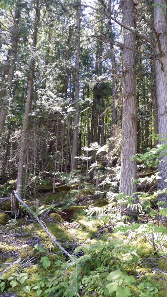
Come and experience Glacier’s pristine forests, alpine meadows, rugged mountains, and spectacular lakes. With over 700 miles of trails, Glacier is a hiker’s paradise for adventurous visitors seeking wilderness and solitude. Relive the days of old through historic chalets, lodges, transportation, and stories of Native Americans. Explore Glacier National Park and discover what awaits you.

Glacier National Park
In 1910, Congress established Glacier National Park in Montana. Conservationist George Bird Grinnell played a key role in the creation of this park in order to preserve the land’s natural beauty. Indians have always revered this region. The Blackfeet, Salish, and Kootenai Indians, who have lived in the area for hundreds of years, consider it a sacred place.

glacier-parkGlacier National Park is named for the glaciers that produced its landscape. A glacier is a moving mass of snow and ice. It forms when more snow falls each winter than melts in the summer. The snow accumulates and presses the layers below it into ice. The bottom layer of ice becomes flexible and therefore allows the glacier to move. As it moves, a glacier picks up rock and gravel. With this mixture of debris, it scours and sculptures the land it moves across. This is how, over thousands of years, Glacier National Park got all its valleys, sharp mountain peaks, and lakes. There are more than 50 glaciers in the park today, though they are smaller than the huge ones that existed 20,000 years ago.

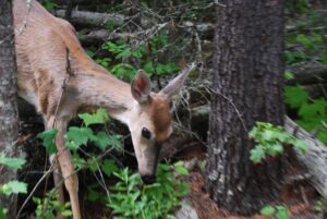
In addition to its glaciers, mountains, and valleys, Glacier National Park covers approximately 1.4 million acres and includes 200 lakes and streams. The park is also home to many different types of wildlife, including black and grizzly bear, moose, golden and bald eagle, bighorn sheep, mountain goat, and whitetail and mule deer.

Glacier National Park is a stunningly beautiful ice-carved terrain of serrated ridges, jutting peaks, dramatic hanging valleys, 50 glaciers, more than 200 lakes, waterfalls and thick forests covering some 1.2-million acres. Deer are among the most commonly spotted wildlife but elk, moose, mountain goats, bighorn sheep, wolves, grizzly and black bears roam its wild vastness and are often seen by visitors.

Goat Lick overlook, for example, is a natural salt lick on cliffs overlooking the southern border of the park. From a viewing platform just off US Highway 2 east of Essex you are sure to see mountain goats or other animals at any time of day enjoying the lick.

Wild flowers, too, are abundant and put on a lengthy show of color as they follow spring up the mountains all summer long.

Hiking in Glacier National ParkThe park is unique among US parks in its relationship with the Waterton Lakes National Park in Alberta, Canada. The two parks meet at the border shared by the two countries. Though administered by separate countries, the parks are cooperatively managed in recognition that wild plants and animals ignore political boundaries and claim the natural and cultural resources on both sides of the border. In 1932, the parks were designated the first International Peace Park in recognition of the bonds of peace and friendship between the two nations. The two parks jointly share the name The Waterton-Glacier International Peace Park. Then, in 1995, The Waterton-Glacier International Peace Park was designated for inclusion as a World Heritage Site.

Visitor Centers
Glacier National Park is served by three Visitor Centers; Apgar, Logan Pass and St. Mary’s. Ranger-guided-naturalist activities are available throughout the park from mid-June through September. Call 406-888-5441 for details. You might like to enquire about having lunch on a glacier! The park has more than 700 miles of trails ranging from day hikes to extended treks. Trailheads for popular day hikes can be found near the visitors’ centers

Going-to-the-Sun Road
The famed 52-mile Going-to-the-Sun Road climbs 3,000 feet to provide spectacular views across the Continental Divide from June to October. It is closed the rest of the year due to heavy snows. Glacier Park Inc. operates a daily shuttle service along this road, from July 1 to Labor Day Weekend in September. The shuttle operates between Rising Sun Motor Inn and Lake McDonald Lodge, a useful service for those who have oversized rigs not allowed on the road, and others who would rather not drive the narrow mountain roads themselves.

History
Earlier this century, the Great Northern Railway built chalets to market Glacier National Park as the “Switzerland of America”. Although many no longer exist, Granite Park Chalet and Sperry Chalet are open to the public. Be warned that the former has no running water. The most popular route to Granite Park Chalet is a 7-mile hike along the Highline Trail from Logan Pass. Glacier Park Lodge, and Many Glacier Hotel also accommodate guests.

Glacier National Park, A Historical Overview

Before the Park

hiking in glacierRecent archaeological surveys have found evidence of human use dating back over 10,000 years. These people may have been the ancestors of tribes that live in the area today. By the time the first European explorers came to this region, several different tribes inhabited the area. The Blackfeet Indians controlled the vast prairies east of the mountains. The Salish and Kootenai Indians lived and hunted in the western valleys. They also traveled east of the mountains to hunt buffalo.
In the early 1800’s, French, English, and Spanish trappers came in search of beaver. In 1806, the Lewis and Clark Expedition came within 50 miles of the area that is now the park.

As the number of people moving west steadily increased, the Blackfeet, Salish, and Kootenai were forced onto reservations. The Blackfeet Reservation adjoins the east side of the park. The Salish and Kootenai reservation is southwest of Glacier. This entire area holds great spiritual importance to the Blackfeet, Salish, and Kootenai people.

The railroad over Marias Pass was completed in 1891. The completion of the Great Northern Railway allowed more people to enter the area. Homesteaders settled in the valleys west of Marias Pass and soon small towns developed.

Under pressure from miners, the mountains east of the Continental Divide were acquired in 1895 from the Blackfeet. Miners came searching for copper and gold. They hoped to strike it rich, but no large copper or gold deposits were ever located. Although the mining boom lasted only a few years, abandoned mine shafts are still found in several places in the park.

Establishing the Park

Around the turn of the century, people started to look at the land differently. Rather than just seeing the minerals they could mine or land to settle on, they started to recognize the value of its spectacular scenic beauty. Facilities for tourists started to spring up. In the late 1890’s, visitors arriving at Belton (now called West Glacier) could get off the train, take a stagecoach ride a few miles to Lake McDonald, and then board a boat for an eight mile trip to the Snyder Hotel. No roads existed in the mountains, but the lakes allowed boat travel into the wilderness.
Soon people, like George Bird Grinnell, pushed for the creation of a national park. Grinnell was an early explorer to this part of Montana and spent many years working to get the park established. The area was made a Forest Preserve in 1900, but was open to mining and homesteading. Grinnell and others sought the added protection a national park would provide. Grinnell saw his efforts rewarded in 1910 when President Taft signed the bill establishing Glacier as the country’s 10th national park.

After the creation of the park, the growing staff of park rangers needed housing and offices to help protect the new park. The increasing number of park visitors made the need for roads, trails, and hotels urgent. The Great Northern Railway built a series of hotels and small backcountry lodges, called chalets, throughout the park. A typical visit to Glacier involved a train ride to the park, followed by a multi-day journey on horseback. Each day after a long ride in the mountains, guests would stay at a different hotel or chalet. The lack of roads meant that, to see the interior of the park, visitors had to hike or ride a horse. Eventually, the demand for a road across the mountains led to the building of the Going-to-the-Sun Road.

A Heritage for the Future

Hiking in Glacier Natinal ParkThe construction of the Going-to-the-Sun Road was a huge undertaking. Even today, visitors to the park marvel at how such a road could have been built. The final section of the Going-to-the-Sun Road, over Logan Pass, was completed in 1932 after 11 years of work. The road is considered an engineering feat and is a National Historic Landmark. It is one of the most scenic roads in North America. The construction of the road forever changed the way visitors would experience Glacier National Park. Future visitors would drive over sections of the park that previously had taken days of horseback riding to see.
Just across the border, in Canada, is Waterton Lakes National Park. In 1931, members of the Rotary Clubs of Alberta and Montana suggested joining the two parks as a symbol of the peace and friendship between our two countries. In 1932, the United States and Canadian governments voted to designate the parks as Waterton-Glacier International Peace Park, the world’s first. More recently the parks have received two other international honors. The parks are both Biosphere Reserves, and were named as a World Heritage Site in 1995. This international recognition highlights the importance of this area, not just to the United States and Canada, but to the entire world.

While much has changed since the first visitors came to Glacier, it is possible to relive some of Glacier’s early history. You can take a horseback ride like an early visitor. Miles of hiking trails follow routes first used by trappers in the early 1800’s. Several hotels and chalets, built by the Great Northern Railway in the early 1900’s, house summer guests to the park. A visit to Glacier National Park is still a great adventure!