The Flathead Lake Vacation Guide

Sunset over Flathead Lake

The Flathead Lake Vacation Guide includes annual events, lodging, trail heads for hiking, private campgrounds and information about every State Park around Flathead Lake. Find out more….

The Guide contains more than 70 pages of information including links to activities, local business listings, , public campgroundshiking trailsfishing access sites and just about any other information you want when you vacation on Flathead Lake.

The Flathead Lake Vacation Guide is easy to use. The Guide contains information about each community, complete with business listings and public access points.  The Guide also contains many of the Trail Heads along Glacier View road, as well as the Jewel Basin outside of Bigfork Montana.

The Flathead Lake Vacation Guide

The Guide contains every public access point around The Lake. It also contains most every private campground as well. So if you are looking for public or private campgrounds around our Lake, this vacation guide has the information you will need to plan your Montana vacation.

Flathead Lake Vacation Guide

Communities on Flathead Lake

Communities included in the Guide include the population centers such as Bigfork, Lakeside and Polson, as well as the smaller communities like Woods Bay, Finely Point or Big Arm. All of the Montana State Parks are listed in this vacation guide. Including Yellow Bay, Flathead Lake Trail and Finley Point State Park. The guide contains many photographs as well as information you will want during your vacation.

The guide costs $6.99 and is an instant download to your computer or mobile device. Of course the Guide comes with a money back guarantee. It’s like having all of the local information right on your phone.

Purchase your guide, either for your phone on in you hand.

The Flathead Lake Vacation Guide.

Flathead Lake Trail Heads

The Flathead Lake Vacation Guide includes annual events, lodging, trail heads for hiking, private campgrounds and information about every State Park around Flathead Lake. Find out more….

The Guide contains more than 70 pages of information including links to activities, local business listings, , public campgroundshiking trailsfishing access sites and just about any other information you want when you vacation on Flathead Lake.

The Flathead Lake Vacation Guide is easy to use. The Guide contains information about each community, complete with business listings and public access points.  The Guide also contains many of the Trail Heads along Glacier View road, as well as the Jewel Basin outside of Bigfork Montana.

Communities on Flathead Lake

Communities included in the Guide include the population centers such as Bigfork, Lakeside and Polson, as well as the smaller communities like Woods Bay, Finely Point or Big Arm. All of the Montana State Parks are listed in this vacation guide. Including Yellow Bay, Flathead Lake Trail and Finley Point State Park. The guide contains many photographs as well as information you will want during your vacation.

The guide costs $6.99 and is an instant download to your computer or mobile device. Of course the Guide comes with a money back guarantee. It’s like having all of the local information right on your phone.

Golf on Flathead Lake. Flathead Lake Vacation Guide

The Flathead Lake Vacation Guide

the Guide contains every public access point around The Lake. It also contains most every private campground as well. So if you are looking for public or private campgrounds around our Lake, this vacation guide has the information you will need to plan your Montana vacation.

Purchase your guide, either for your phone on in you hand.

The Flathead Lake Go Hike With Mike Trailguide in Paperback

The Go Hike With Mike Trail Guide in paperback

Lone Trails second publication, the Flathead Lake Trailguide, Go Hike with Mike has been such a success. Thank you. We are now offering the trail guide in paperback.  So without further ado, may we present The Trail Guide in Paperback.

#GoHikeWithMike

The Go Hike With Mike Trailguide

Flathead Lake Trailguide
The Go Hike With Mike Trail Guide in Paperback

See you on the Trail

This website contains information about camping & hiking around Flathead Lake.   Mike has been hiking, wandering, hunting and spending time in these woods for more then 30 years.  The Guide contains most every trail head around Flathead Lake.  The guide includes trails as far north as Polebridge.  It also contains the Hungry Horse recreation area, the Swan Front and Swan Valley to the east.  To the north the guide contains trail head and campground information around Tally Lake.

Flathead Lake Trailguide

Mike receives countless inquires about good trails and camping spots around Flathead Lake.  There is clearly a need for more detailed information about hiking around Flathead Lake.  This website and trail guide are the trails Mike would like to recommend to you during your visit to northwest Montana.

The trail guide is focused on trails, camping and being in the woods.  Mike’s Flathead Lake Trail Guide breaks the area into these sections.  North of Flathead lake, including The Talley Lake area and due north to Polebridge. East of Flathead Lake, including the Swan Front, Swan Valley, and on into the Hungry Horse recreation area.   The guide contains most every trail Mike has hiked in the last 30 years or plans to hike in the next 20 years.

The Flathead Lake Vacation Guide in Paperback

Flathead Lake Vacation Guide in paperback

Thank you for ten years of creating and finetuning the Flathead lake Vacation Guide. For our tenth anniversary we have published the vacation guide in paperback.  we have receive hundreds of requests over the last ten years, and now, for the first time , may we present The Flathead Lake Vacation Guide in Paperback.

Flathead Lake Vacation Guide in Paperback

Flathead Lake Vacation Guide in Paperback

The Ultimate Flathead Lake Vacation Guide Paperback

There are thirteen public access sites around Flathead Lake Montana. These access sites include: Sportsmans Bridge, Somers, Big Fork, and Juniper Beach fishing access sites; Wayfarers, Woods Bay, Yellow Bay, Finely Point, Walstad Memorial, Big Arm, and Elmo state recreation areas, which have toilets, boat launch, camping, swimming and picnic facilities. All of these access points are included in the Flathead Lake Vacation Booklet.

Another park is The West Shore State Park, located is twenty miles south of Kalispell on Highway 93. Also located along the west shore near the Big Arm is Wildhorse Island, a 2,165-acre state park. The park is accessible only by boat and is a public day use and picnic area only, no overnight camping.

Above all, recreation activities around the lake include: sailing, power boating, waterskiing, swimming, fishing, hiking, and camping. Summertime on Flathead Lake includes roadside fruit stands along the east shore. Many offer a variety of locally grown cherries, apples, plums, and other fruits. There are numerous motels and rental cabins in addition to public campgrounds scattered all around the shoreline. The population centers around the lake are Lakeside, Bigfork, and Polson, all of which offer a complete variety of groceries, supplies, and information.

Elk Ridge Trail #301

The Elk Ridge trail, also known as Mollman Lakes trail, is 10.5 miles long and climbs about 3,100 feet.  This trail has two trailheads, one off of Forest Service Rd #903 and one off of Forest Service Rd #9591 which is open from 12/1-10/14.  This upper trail head cuts about 0.2 miles off of the route.

Hiking in Montana
Hiking in Montana

The trail follows closed roads for 2.7 miles before turning into the woods.  This trail leads up a closed road bed (#10291), the trail turns right at a T intersection in a large grassy area where two roads meet.  After turning right the trail leaves the old road to the left less than 1/10 of a mile after the intersection.  This trail is not regularly maintained past 5.4 miles, please be sure you are comfortable traveling cross country and have a map and compass if you continue past this point.

Click Here for the NFS Trail Map and Directions

Mountain biking is not allowed in the wilderness.  Biking is allowed to the wilderness boundary approximately 4  miles from the lower trailhead.  This is a gentle bike ride on old forest roads.

Follow Mike on Instagram or subscribe to his YouTube Channel

#gohikewithmike

Hikes around Flathead Lake.

Going for a hike… Don’t forget Mike, The Go Hike With Mike Trail Guide.

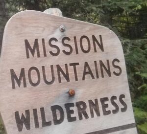
If you are hiking in the mountains around Flathead Lake, you are in the Mission mountain Range.  The Mission Mountain Range is not only Grizzly Bear habitat but the west side of it resides in Indian Country.  With that said, when hiking in the Missions on the Flathead Indian Reservation, be sure to have bear spray and a tribal recreation permit. Once you have those two items enjoy your trails.  Be aware the Mission Mountain Range is a Wilderness Area.  This designation imposes additional regulations on mechanized operation.

If you are on US Highway 35 heading North, around Bear Dance Trail Head and the Flathead Lake Trail you are no longer on the reservation. North or South have bear spray and know how to use it.

Mission Mountains Wilderness

Hikes around Flathead LakeThe Mission mountain Wilderness will offer you impressive mountain views, and lakes.  You can expect wild landscapes with an ample amount of solitude.

There is an good trail system leading to the more popular lakes. The Mission Mountain range  has something for every type of recreationalist. A simple day hike might be Glacier Lake, or, if your feeling lucky, grab your bear spray and head out to Mollman Lakes.

The Mission Mountains Wilderness is bordered by the Salish- Kootenai tribal wilderness; please contact 406-675-2700 for information regarding access and use.

Recreation areas with activity Day Hiking:

Purchase The Go Hike With Mike Trail Guide.

Don’t need the hiking guide, just some basic trail information, do not fret.  Mike has included some beginner to medium hikes on this website.  Depending on were you as staying there is most likely a trail head near you. Thanks for visiting, hope to see you on the trail.

Other Trails


Glacier Creek Trail #690
Hemlock Feeder Trail #695
Hemlock Lake Trail #607
Hemlock Peak Trail #515
Jocko Trail #34
Piper Lake Trail #119
Turquoise Lake Trail #708

Backpacking
Recreation areas and trails.

Cedar Lake Trail #738
Elk Ridge Trail #301
Hemlock Lake Trail #607
Hemlock Peak Trail #515
Jocko Trail #34
Piper Lake Trail #119
Turquoise Lake Trail #708

Cedar Lake Trail #738.

Cedar Lake Trail
Cedar Lake Trail

The Cedar Lake Trail is 7.0 miles long. It begins at end of Road #10381 (seasonally open from 6/15-3/31) and ends at the junction with the Piper Creek trail #119 which continues to Piper Lake.

The whole trail from portal to portal is 13 miles and climbs up to 6880 feet in elevation. Most of this trail is in Wilderness and so is open for the following uses: hiking and horseback riding.

Cedar Lake Trail

Click Here for Flathead National Forest Trail Map and Directions

Follow Mike on Instagram or subscribe to his YouTube Channel

#gohikewithmike

Another Hiking Video from Go Hike With Mike.

Hiking around Flathead Lake

Thank you for enjoying this hiking video with Mike. Hope to see you on the trail soon.

[embedyt] https://www.youtube.com/watch?v=CyHdRucBpvE[/embedyt]

Please enjoy this Hiking Video:

See you on the Trail

The Go Hike with Mike Trail Guide contains information about camping & hiking around Flathead Lake.   Mike has been hiking, wandering, hunting and spending time in these woods for more then 20 years.  The Go Hike with Mike Trail Guide contains most every trail head around Flathead Lake.  The guide includes trails as far north as Polebridge.  It also contains the Hungry Horse recreation area, the Swan Front and Swan Valley to the east.  To the north the guide contains trail head and campground information around Tally Lake.

Don’t need the hiking guide, just some basic trail information, do not fret.  Mike has included some beginner to medium hikes on this website.  Depending on were you as staying there is most likely a trail head near you. Thanks for visiting, hope to see you on the trail.

190 pages packed with trailheads, camping spots, and local information around Flathead Lake.

Another Flathead Lake Video

Sunset on Flathead Lake

[embedyt] https://www.youtube.com/watch?v=cXx09Gv-oc0[/embedyt]

How to Purchase Montana’s Flathead Lake Guide.

At $6.99 the Vacation Guide Download costs less then a Subway® sandwich you can buy in Bigfork or Polson. So this will insure you have the information you need to have a Great Montana Lake VacationPurchase your downloadable guide using our Pay-Pal option knowing your information is safe and secure and we will see you on the Lake!

Purchase the Flathead Lake Vacation Guide 

Montana’s Flathead Lake Vacations are better with this downloadable guide. The booklet includes restaurants, hotels, motels, vacation rentals, boat rentals, water craft rentals as well as public and private campgrounds.

It is the most complete vacation information about Flathead Lake. Download your copy today!

About Flathead Lake

#MontanasFlatheadLake

There are  185 miles of shoreline and 200 square miles of natural  freshwater.  Therefore earning the title as “the largest natural freshwater lake west of the Mississippi”.  There are 13 public access sites around The Lake maintained by  Montana Fish Wildlife and Parks

Flathead Lake

The southern half of The Lake lies within the boundary of the Confederated Salish and Kootenai Tribes’ Flathead Reservation, which was created in 1855 by the Hellgate Treaty. The Flathead Nation insists that all non-tribal members purchase a tribal recreation permit to recreate on tribal lands.

Hiking Trails: Camp Misery Trail

Go Hike With Mike Trail Guide

Hiking Trail: Camp Misery Trail #68

The Camp Misery trail is 0.8 miles long. It begins at the junction with Noisy Creek Trail #8 and ends at the junction with Alpine Trail #7 and provides one of the many accesses into the Jewel Basin Hiking Area. The trail is primarily open for the following uses: Hiking.

Usage is typically light, closest town is Bigfork
Camp Misery TrailDirections:
From Bigfork, go North on Highway 35 for 2.3 miles and turn right onto Highway 83. Stay on 83 for 2.8 miles and turn left onto Echo Lake Rd. After 2.2 miles, turn slightly right onto Foothill Rd. Continue for 1.1 miles and bear slight right following the Jewel Basin sign onto Road #5392. Continue 6.6 miles to the end of the road for the trailhead.


Location

Area/Length : 0.8 miles
Elevation : 5,750 feet – 7,530 feet

190 pages packed with trailheads, camping spots, and local information around Flathead Lake.

Don’t need the hiking guide, just some basic trail information, do not fret.  Mike has included some beginner to medium hikes on this website.  Depending on were you as staying there is most likely a trail head near you. Thanks for visiting, hope to see you on the trail.
The trail guide is focused on trails, camping and being in the woods.  Mike’s Mike’s Go Hike With Mike Flathead Lake Trail Guide breaks the area in five easy to use sections.  North of Flathead lake, including The Talley Lake area and due north to Polebridge. East of Flathead Lake, including the Swan Front, Swan Valley, and on into the Hungry Horse recreation area.  The guide contains most every trail Mike has hiked in the last 20 years or plans to hike in the next 20 years.