The National Bison Range was established in 1908 and is one of the oldest Wildlife Refuges in the nation. The Range is about 25 miles south of Montana’s Flathead Lake.
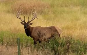
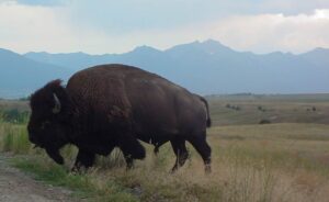 A large portion of the 18, 500 acre Range consists of native Palouse prairie; forests, wetlands, and streams are also found here providing a wide range of habitats for wildlife. Elk, deer, pronghorn, black bear, coyote and ground squirrels are just some of the mammals that share the area with 350 to 500 bison. Over 200 species of birds also call this home including eagles, hawks, meadowlarks, bluebirds, ducks, and geese.
General Information
Fees are charged during the summer (mid-May to late October). The Range is part of the U.S. Fee System and accepts Golden Passes and Federal Waterfowl Stamps. Pay fees at the Visitor Center.
The Range is closed at night. Check the Contact Us page for current hours.
Camping is not allowed on the Range.
Visitor Center
The best place to start your visit is at the Visitor Center. Here you will find informative displays and handouts, restrooms, videos, a bookstore, and staff to answer your questions. Pay entrance fees here. For more information about the Bison Range and other activities in northwest Montana, consider purchasing a copy of the Flathead Lake Vacation Guide.
Auto Tours
 Prairie Drive/West Loop: a 5-mile gravel road that travels through the flats. It is open to trailers and large RVs. It goes by the Bison Display Pasture. Plan for 1/2 hour. Open year round.
Red Sleep Mountain Drive: a 19-mile, one-way, gravel road which gains 2,000feet. There are many switchbacks and 10% grades along the drive. No trailers or vehicles over 32 feet are allowed on this drive. Allow 1 1/2 to 2 hours. Open mid-May to late October. (Check the Contact Us page for current information.)
Walking Trails: Hiking is limited on the Range to a few short walking trails. A mile-long Nature Trail is located at the Picnic Area and 1/4-mile Grassland Trail is at the Visitor Center. The 1/2-mile Bitterroot Trail and 1-mile High Point trail are both located off the Red Sleep Mountain Drive. Walking away from your vehicle is prohibited except for these designated trails. For a complete listing of trails around Flathead Lake, see the Go Hike With Mike Trail guide.
Picnic Area
The Range has a picnic area near Mission Creek. There are tables, grills, water, and accessible toilets. A covered pavilion is available on a first-come, first-served basis. There are no garbage cans, so please pack out all trash.
How to get here:
From Missoula: Travel north on US Highway 93 to Ravalli, turn left(to the west) on to State Highway 200, travel approximately 5 miles to the junction of Highways 200 and 212, turn right(to the north) and travel approximately 5 miles to the entrance of the Range at Moiese.
From Kalispell: Travel south on US Highway 93 or State Highway 35 to Polson, then travel Highway 93 through Pablo and Ronan to the junction of Highway 93 and State Highway 212, travel 12 miles (through Charlo) to the entrance of the Range at Moiese.
From the west: Travel Highway 200 through Dixon to the junction of Highways 200 and 212, turn left(to the north) and travel approximately 5 miles to the entrance of the Range at Moiese.


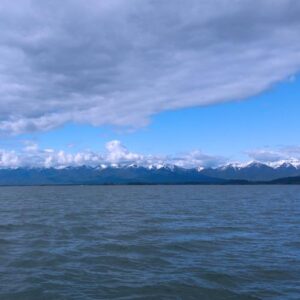 Flathead Lake is the largest natural freshwater lake in the western United States. Lying in the Flathead Valley of Northwest Montana, the lake is more then 300 feet deep and extends north and south some 28 miles and is seven to 15 miles wide.
 You can avail yourself of a boat tour or rent one of the many types of watercraft including canoes, kayaks, windsurfers, hydro bikes, sailing and fishing boats. Serious anglers can arm themselves with heavy-duty equipment and probe the 300-foot deep Flathead Lake for trophy Mackinaw. Lake trout, salmon, perch, pike, bass, and whitefish are found in the Flathead area’s many lakes.


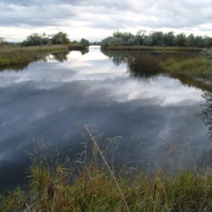 Photography and wildlife observation are encouraged. Waterfowl numbers vary throughout the year. There may be as many as 80,000 in October and November, and half that number in late March and through early May. A few ducks and geese may spend the winter. Nesting begins in late March and lasts through July. The most numerous nesting species are Canada geese, mallards, and redheads. Pintail, American widgeon, shoveler, blue and green-winged teal, ruddy duck, gadwall, common merganser, and coot are also present. Other species of water, marsh, and upland birds are abundant from May to October. Common loons are occasionally seen and this is a good area to see Bald Eagles.


 The trail guide is focused on trails, camping and being in the woods. Mike’s